Google frequently touts that the “next billion users” will come from developing nations with different focuses and needs. To that end, the company has developed several optimized services, with one being a consistent and straightforward addressing system that works globally.
Google created “Plus Codes”for addresses that are not easily located through conventional descriptors. First introduced in February 2018, Plus Codes allow users to locate almost any spot on the planet. What many people in traditional civilizations fail to realize is that, according to a World Bank estimate, half of the world’s urban population lives on unnamed streets.
Notably, this open source solution composed of 10 characters works globally and can be incorporated by other products and platforms for free, with a developer page available here.
It works offline and in print when overlaid as a grid on existing maps. Places that are close together share similar plus codes, while the system is identifiable by the “+” symbol in every address.
This system is based on dividing the geographical surface of the Earth into tiny ‘tiled areas,’ attributing a unique code to each of them. This code comprises a ‘6-character + City’ format that can be generated, shared and searched by anyone – all that’s needed is Google Maps on a smartphone.
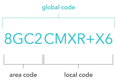
• The first four characters are the area code, describing a region
of about 100 x 100 kilometers.
• The last six characters are the local code, describing the neighborhood
and the building, an area of approximately 14 x 14 meters – about the
size of one half of a basketball court.
The area code is not needed when navigating within a town, while another optional character can be appended to provide additional accuracy down to a 3 x 3-meter region. Plus codes for any location can be found with this tool.
Google created “Plus Codes”for addresses that are not easily located through conventional descriptors. First introduced in February 2018, Plus Codes allow users to locate almost any spot on the planet. What many people in traditional civilizations fail to realize is that, according to a World Bank estimate, half of the world’s urban population lives on unnamed streets.
Notably, this open source solution composed of 10 characters works globally and can be incorporated by other products and platforms for free, with a developer page available here.
It works offline and in print when overlaid as a grid on existing maps. Places that are close together share similar plus codes, while the system is identifiable by the “+” symbol in every address.
This system is based on dividing the geographical surface of the Earth into tiny ‘tiled areas,’ attributing a unique code to each of them. This code comprises a ‘6-character + City’ format that can be generated, shared and searched by anyone – all that’s needed is Google Maps on a smartphone.
• The first four characters are the area code, describing a region
of about 100 x 100 kilometers.
• The last six characters are the local code, describing the neighborhood
and the building, an area of approximately 14 x 14 meters – about the
size of one half of a basketball court.
The area code is not needed when navigating within a town, while another optional character can be appended to provide additional accuracy down to a 3 x 3-meter region. Plus codes for any location can be found with this tool.


 RSS Feed

